
Know Which Motion Matters
Perimeter security cameras detect motion. The problem is that outdoors, everything moves.
Animals move. Vegetation moves. Shadows, headlights, debris, service activity, weather, and equipment can all create motion across a large outdoor scene. If every movement becomes an alarm, operators stop trusting the system. If sensitivity is reduced too far, real intrusions can be missed.
SightLogix Geospatial Intelligence was built to solve that problem.
SightSensors do not treat motion as a simple change in pixels. They interpret motion in real-world terms: how large the object is, how far away it is, where it is located, how fast it is moving, what direction it is traveling, and whether that behavior matches the site’s detection rules.
That real-world awareness is foundational to accurate perimeter detection. It helps the camera determine whether motion is consistent with a real threat, whether it should be ignored, and whether it should be passed forward for AI classification and alarm generation.
For large outdoor perimeters, this difference matters. A camera that only sees motion can create noise. A camera that understands motion in real-world terms can create a trusted alert.
From Motion to Accurate Detection
At long range, accurate detection depends on knowing more than the fact that something moved.
SightLogix calculates the actual size and distance of moving objects, not just how large they appear in the image. That distinction is critical because apparent size changes with distance. A nearby animal may appear significant in the frame, while a valid target farther away may appear small. The camera needs to ignore the animal and detect the person. Every time.

By evaluating actual size and distance, SightLogix can determine whether motion matches the expected dimensions of a relevant target. That improves alarm quality in two ways: it helps reject motion that does not fit the threat profile, and it helps preserve detection sensitivity for real targets at distance.
Detection Policies That Match the Site
Every site has its own perimeter logic. A gate, road, transformer, data hall, fence line, loading area, or restricted zone may each require different rules.
Because SightLogix understands the scene in real-world coordinates, security teams can create detection rules that reflect how the site actually operates.
Geospatial analytics can support:
- Detection zones around fences, gates, buildings, roads, or high-value assets
- From-to rules that alarm when movement is headed toward a protected area
- Mask zones to ignore roads, public areas, or expected site activity
- Size filtering based on actual target dimensions
- Speed and direction rules to identify suspicious movement patterns
- Bearing and location data for faster event assessment and response
These rules help the system focus on meaningful perimeter activity. The goal is not simply to detect motion. The goal is to detect relevant motion in the right place, moving in the wrong way, at the wrong time.
AI Classification After Geospatial Filtering
SightLogix uses geospatial intelligence and AI as part of the same detection workflow.
Geospatial rules help determine whether a moving object is a credible alarm candidate based on its real-world behavior: size, location, distance, direction, speed, and zone activity. AI classification can then be applied to confirm whether the object is a person or vehicle when there are enough pixels on target.
That sequence matters.
AI is not asked to classify every moving object across the entire outdoor scene. The system first uses geospatial context and site rules to decide whether the motion is relevant. Then AI helps confirm the target type.
This layered approach helps reduce nuisance alarms without weakening the sensitivity required for reliable perimeter detection.
Automatic PTZ Steering and Target Tracking
Geospatial intelligence also enables automated visual assessment.
When a SightSensor detects a target, the system knows where that target is in the real world. That location can be used to steer SightTracker PTZ to the event, zoom in, and follow the target as it moves.
Operators do not have to manually search a wide outdoor scene or guess where to point a PTZ camera. SightSensor detects and locates the target. SightTracker PTZ provides visual context for verification and response.
For large sites, remote substations, data centers, airports, logistics yards, and other expansive facilities, that automation can save critical time.

Making Geo-Registered Analytics Easy
Geospatial intelligence is powerful, but it does not require a complicated setup process.
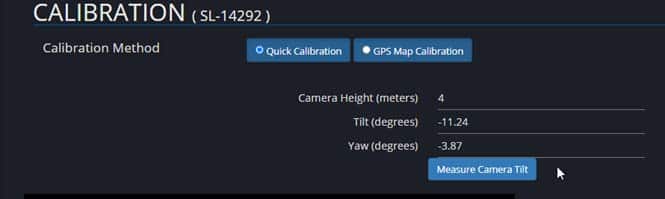
During setup, the installer enters the camera height. Built-in sensors determine camera tilt and yaw. From there, processing inside the camera uses geometry to calculate the real-world distance, size, and location represented throughout the scene.
SightSensors perform this analysis continuously at video frame rate, interpreting target size, distance, speed, direction, and bearing as events unfold.
This setup enables the system to apply geospatial rules, locate detections on the site, and steer PTZ cameras automatically without requiring operators to interpret the scene manually.
The Bottom Line
Geospatial intelligence is a foundational part of the SightLogix detection architecture.
By understanding the real-world size, distance, location, speed, direction, and bearing of moving objects, SightLogix helps determine which motion matters, reduce nuisance alarms, support more accurate AI classification, guide response, and automatically steer PTZs to the event.
For high-security outdoor perimeters, knowing that something moved is not enough. Operators need to know where it is, what it is doing, where it is going, and whether the alarm can be trusted.
Additional Resources & Information

Our Products
Our Smart Thermal Cameras
Safeguard high-value perimeters with edge-based thermal detection, dual-sensor thermal-visible systems, and PTZ tracking—detecting intruders day or night, in any weather.

Our Solutions
Industry-Proven Thermal Protection
Dual sensor analytics secures critical infrastructure and commercial facilities across vast perimeters, reduce false alarms by ninety-five percent.

Get Support
Mission-Critical Support
Reach certified engineers by phone or portal for design reviews, firmware updates, rapid troubleshooting, and proactive fleet health checks worldwide.
Product Demo
See SightLogix In Action
Watch live or recorded demonstrations where smart thermal cameras detect, classify, and auto-track threats across challenging weather, distances, and layouts.